EDITORIAL: Proposal ignores flood realities
Article content
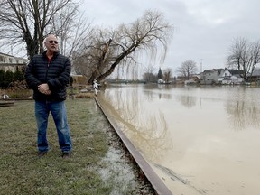
This year has been one of the driest in recent memory, but 2021 was among the wettest. And for the past several years, water levels in our lakes have been near historic highs – and still remain above historical averages.
What that means for homeowners is a certain amount of unpredictability. Rainfall in Southwestern Ontario can be capricious, withholding its volume one year, and unleashing it with great fury the next.
Managing that precipitation, whether it be snowmelt or rainfall – and the potential for flooding from either – can be delicate, but a task for which our conservation authorities were established. They monitor water levels, enact conservation programs, help establish flood zones and advise municipalities on planning issues as they relate to development on lands prone to flooding.
In recent decades there has been little conflict between development and flood zones, but that’s changing as pressure mounts to build more homes for Ontario’s growing population. The provincial government on Oct. 25 introduced legislation to help build 1.5 million new homes within the next 10 years. The legislation would reduce development fees, allow more units on one residential lot and limit the powers of conservation authorities in planning.
The latter proposal should be of great concern. The government wants to prevent municipalities from entering into agreements with conservation authorities to review planning applications, ostensibly to push greater development.
The province is also proposing that some municipalities become exempt from getting natural hazard permits, which are now provided by conservation authorities for developments that could affect or be affected by those hazards.
These proposals ignore the change in climate that has affected Ontario and particularly the Great Lakes region, and the potential for greater flooding and significant property damage.
Indeed, conservation authorities were established almost 70 years ago for this very purpose. The impact of Hurricane Hazel in 1954 alerted the public and politicians to the problem of widespread flooding. The Toronto and Region Conservation Authority was subsequently created to manage floodplains and rivers. Heavily flooded areas were expropriated and those lands converted to an extensive park system.
The same principles were extended to other regions. Extensive flooding in Dresden and Wallaceburg in 1947 prompted the establishment in 1961 of the Sydenham Valley Conservation Authority, renamed the St. Clair Region Conservation Authority.
It would be foolhardy to ignore the accumulated intelligence of conservation authorities when property with a history of flooding is being considered for development. But yet that’s exactly what the province’s legislation proposes to do.
-Peter Epp
Postmedia is committed to maintaining a lively but civil forum for discussion. Please keep comments relevant and respectful. Comments may take up to an hour to appear on the site. You will receive an email if there is a reply to your comment, an update to a thread you follow or if a user you follow comments. Visit our Community Guidelines for more information.